


La Chartreuse de la Verne

trailer.nono
User
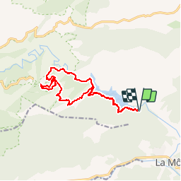

Length
15.3 km

Max alt
455 m

Uphill gradient
487 m
Km-Effort
22 km

Min alt
82 m

Downhill gradient
490 m
Boucle
Yes
Creation date :
2017-02-01 00:00:00.0
Updated on :
2017-02-01 00:00:00.0
1h38
Difficulty : Medium

FREE GPS app for hiking
 SityTrail
IGN / Geographical institutes
SityTrail Plus
The world is yours!
About
Trail Running of 15.3 km to be discovered at Provence-Alpes-Côte d'Azur, Var, La Môle. This trail is proposed by trailer.nono.
Positioning
Country:
France
Region :
Provence-Alpes-Côte d'Azur
Department/Province :
Var
Municipality :
La Môle
Location:
Unknown
Start:(Dec)
Start:(UTM)
292860 ; 4789015 (32T) N.
Comments